Tag archives: LiDAR
Carbon map of Panama leads the way
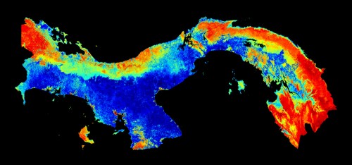
The first high-res national carbon map. (Courtesy: Carnegie Airborne Observatory)
By Madeleine Fowler, who is doing a work experience placement at Physics World
Panama is a country of diverse ecosystems and complex landscapes, with vegetation ranging from grasslands and scrublands to dense forests. This makes it the perfect location for scientists to experiment with different methods of measuring above-ground carbon density – carbon that is locked up in vegetation.
Scientists have now mapped the above-ground carbon density of the entire country, which is a first in the world of carbon mapping. Field data and satellite data were integrated with high-resolution airborne light detection and ranging (LiDAR) data. This made it possible to create the first carbon map that could quantify carbon stocks in a local area as small as one hectare. What’s more, it can do this over millions of hectares.
View all posts by this author | View this author's profile